![](/images/other/stat-length.png)
![Trail Le Mesnil-sous-Jumièges - 2020-06-11_12h41m21_Cirkwi-Les_Vergers - Photo](https://media.geolcdn.com/t/1900/400/ext.pjpeg?maxdim=2&url=https%3A%2F%2Fsecurestorage.geolives.com%2Fsitytour%2Ftrail-bg%2Fdefault.jpg)
2020-06-11_12h41m21_Cirkwi-Les_Vergers
© OpenStreetMap contributors
![Length](/images/other/stat-length.png)
Length
6.5 km
![Max alt](https://static1.geolcdn.com/siteimages/upload/files/1508320355ic_sort_altitude_max_24dp.png)
Max alt
56 m
![Uphill gradient](https://static1.geolcdn.com/siteimages/upload/files/1508320355ic_sort_den_pos_24dp.png)
Uphill gradient
90 m
![Km-Effort](/images/other/stat-length.png)
Km-Effort
7.7 km
![Min alt](https://static1.geolcdn.com/siteimages/upload/files/1508320355ic_sort_altitude_min_24dp.png)
Min alt
2 m
![Downhill gradient](https://static1.geolcdn.com/siteimages/upload/files/1508320355ic_sort_den_neg_24dp.png)
Downhill gradient
89 m
![Boucle](https://static1.geolcdn.com/siteimages/upload/files/16400158638029165_repeat_loop_refresh_sync_direction_icon.png)
Boucle
Yes
Creation date :
2020-06-11 10:41:22.068
Updated on :
2020-06-11 10:41:24.09
![Scan this QR Code to open this trail in the SityTrail application](https://capi.geolives.com/qq0zvz2zws4bq2lad0pu/sitytour/trails/2432107/qr.png?size=200)
FREE GPS app for hiking
About
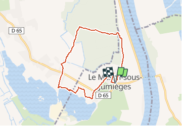
Trail of 6.5 km to be discovered at Normandy, Seine-Maritime, Le Mesnil-sous-Jumièges. This trail is proposed by nicole.reine@wanadoo.fr.
Description
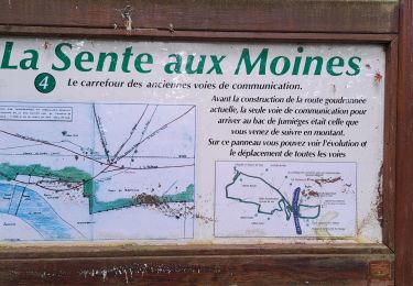
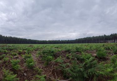
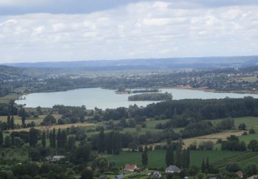
Ce circuit vous emmènera entre forêt et paysage arboricole caractéristique de cette boucle de la Seine dont l'histoire est intimement liée à celle de l'Abbaye de Jumièges. A la sortie de la forêt (prudence en période de chasse), vous traverserez le golf et la base de loisirs. En revenant vers le village vous longerez le Manoir de la Vigne où mourut Agnès Sorel, favorite du roi Charles VII.
Positioning
Country:
France
Region :
Normandy
Department/Province :
Seine-Maritime
Municipality :
Le Mesnil-sous-Jumièges
Location:
Unknown
Start:(Dec)
Start:(UTM)
344616 ; 5475473 (31U) N.
Comments
Trails nearby
![Trail Equestrian Barneville-sur-Seine - Circuit des Côtes - Barneville sur Seine - Photo](https://media.geolcdn.com/t/375/260/ext.jpg?maxdim=2&url=https%3A%2F%2Fservices.sitytrail.com%2FGeolivesWS%2FDownloadMedia.ashx%3FTrailID%3D111652%26Media%3D7891_1.jpg)
![Equestrian Equestrian](https://static1.geolcdn.com/sitytour/trail-icons/300.png)
Circuit des Côtes - Barneville sur Seine
Equestrian
Easy
(1)
Barneville-sur-Seine,
Normandy,
Eure,
France
![](/images/other/stat-length.png)
5.9 km | 8 km-effort
1h 0min
![](https://static1.geolcdn.com/siteimages/upload/files/16400158638029165_repeat_loop_refresh_sync_direction_icon.png)
Yes
![Trail Walking Jumièges - 076-84-Jumièges 14Km La route des Fruits - Photo](https://media.geolcdn.com/t/375/260/e64b558b-b90d-49d1-a272-2fef28aac5a7.jpg&format=jpg&maxdim=2)
![Walking Walking](https://static1.geolcdn.com/sitytour/trail-icons/101.png)
076-84-Jumièges 14Km La route des Fruits
Walking
Easy
(1)
Jumièges,
Normandy,
Seine-Maritime,
France
![](/images/other/stat-length.png)
13.7 km | 14.9 km-effort
3h 19min
![](https://static1.geolcdn.com/siteimages/upload/files/16400158638029165_repeat_loop_refresh_sync_direction_icon.png)
Yes
![Trail Walking Heurteauville - HONFLEUR 04 - La Sente aux Moines et Abbaye de Jumiêges (Normandie) - Photo](https://media.geolcdn.com/t/375/260/010082f5-0545-4d4b-952f-4f2094d18163.jpg&format=jpg&maxdim=2)
![Walking Walking](https://static1.geolcdn.com/sitytour/trail-icons/101.png)
HONFLEUR 04 - La Sente aux Moines et Abbaye de Jumiêges (Normandie)
Walking
Medium
Heurteauville,
Normandy,
Seine-Maritime,
France
![](/images/other/stat-length.png)
19.9 km | 25 km-effort
6h 37min
![](https://static1.geolcdn.com/siteimages/upload/files/16400158638029165_repeat_loop_refresh_sync_direction_icon.png)
No
![Walking Walking](https://static1.geolcdn.com/sitytour/trail-icons/101.png)
20230513-Yainville
Walking
Medium
Yainville,
Normandy,
Seine-Maritime,
France
![](/images/other/stat-length.png)
12.4 km | 14 km-effort
3h 52min
![](https://static1.geolcdn.com/siteimages/upload/files/16400158638029165_repeat_loop_refresh_sync_direction_icon.png)
Yes
![Walking Walking](https://static1.geolcdn.com/sitytour/trail-icons/101.png)
20230302-Barneville sur Seine
Walking
Difficult
Barneville-sur-Seine,
Normandy,
Eure,
France
![](/images/other/stat-length.png)
13.1 km | 16.6 km-effort
3h 31min
![](https://static1.geolcdn.com/siteimages/upload/files/16400158638029165_repeat_loop_refresh_sync_direction_icon.png)
Yes
![Trail Walking Barneville-sur-Seine - Les Grottes de l'Aubrière - Photo](https://media.geolcdn.com/t/375/260/ext.jpg?maxdim=2&url=https%3A%2F%2Fstatic1.geolcdn.com%2Fsiteimages%2Fupload%2Ffiles%2F1553511878bg_sport_marche.png)
![Walking Walking](https://static1.geolcdn.com/sitytour/trail-icons/101.png)
Les Grottes de l'Aubrière
Walking
Medium
(1)
Barneville-sur-Seine,
Normandy,
Eure,
France
![](/images/other/stat-length.png)
23 km | 29 km-effort
6h 23min
![](https://static1.geolcdn.com/siteimages/upload/files/16400158638029165_repeat_loop_refresh_sync_direction_icon.png)
Yes
![Trail Walking Yainville - 20210708-Yainville - Photo](https://media.geolcdn.com/t/375/260/7a3f9508-f365-411b-b734-695f75e8459f.jpg&format=jpg&maxdim=2)
![Walking Walking](https://static1.geolcdn.com/sitytour/trail-icons/101.png)
20210708-Yainville
Walking
Medium
Yainville,
Normandy,
Seine-Maritime,
France
![](/images/other/stat-length.png)
23 km | 27 km-effort
6h 6min
![](https://static1.geolcdn.com/siteimages/upload/files/16400158638029165_repeat_loop_refresh_sync_direction_icon.png)
Yes
![Walking Walking](https://static1.geolcdn.com/sitytour/trail-icons/101.png)
20210617-Mauny
Walking
Medium
Mauny,
Normandy,
Seine-Maritime,
France
![](/images/other/stat-length.png)
13.4 km | 17.1 km-effort
3h 56min
![](https://static1.geolcdn.com/siteimages/upload/files/16400158638029165_repeat_loop_refresh_sync_direction_icon.png)
Yes
![Walking Walking](https://static1.geolcdn.com/sitytour/trail-icons/101.png)
20200207-Barneville Journee
Walking
Difficult
Barneville-sur-Seine,
Normandy,
Eure,
France
![](/images/other/stat-length.png)
22 km | 29 km-effort
6h 35min
![](https://static1.geolcdn.com/siteimages/upload/files/16400158638029165_repeat_loop_refresh_sync_direction_icon.png)
Yes